

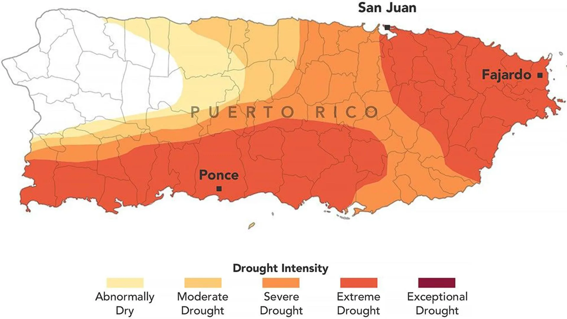
Puerto Rico has experienced a severe and rapidly intensifying drought during 2026, departing significantly from typical weather patterns. The territory, which normally enters its wet season in May, instead faced persistent rainfall deficits throughout the following months. By late August, conditions had deteriorated to the point where the governor declared a state of emergency in late July, and the U.S. government issued a drought disaster declaration for more than two dozen municipalities.
Data from the U.S. Drought Monitor indicated that approximately 75% of Puerto Rico was experiencing at least moderate drought conditions by August 25. The most severe designation—extreme drought—covered 44% of the territory, concentrated primarily in eastern and southwestern portions of the main island. This expansion occurred remarkably quickly, as just three months prior no part of Puerto Rico was classified as experiencing drought, with fewer than 20% of areas considered abnormally dry. The shift represents a dramatic climate reversal following a wetter-than-normal late winter and early spring.
Rainfall measurements underscored the severity of the dry period. From mid-May through mid-July, most regions received less than 60% of normal precipitation, while southern and southwestern areas proved especially arid with less than 20% of typical rainfall amounts. This created deficits ranging from 3 to 6 inches across affected areas. Contributing to the moisture stress, San Juan recorded one of its warmest Julys on historical record, while streamflow in major waterways including the Rio Fajardo reached record lows.
The drought has created substantial impacts across multiple sectors. Water rationing became necessary in several municipalities beginning in early August, with infrastructure limitations exacerbating supply shortages. Agricultural productivity suffered significantly, as dry soil conditions disrupted cultivation of fruit and cacao trees along with banana and coffee plants, resulting in crop losses. Ranchers similarly faced challenges as available hay supplies diminished.
The U.S. Drought Monitor, produced through collaboration between the National Drought Mitigation Center, USDA, NOAA, and NASA, provides weekly assessments used by officials to guide emergency response and resource allocation. The incorporation of satellite soil moisture data, weather measurements, and streamflow observations helps inform these critical designations, which facilitate rapid disaster declarations and direct emergency assistance to affected communities.
Article Attribution | Read More at Article Source
Article summary produced by Claude AI