

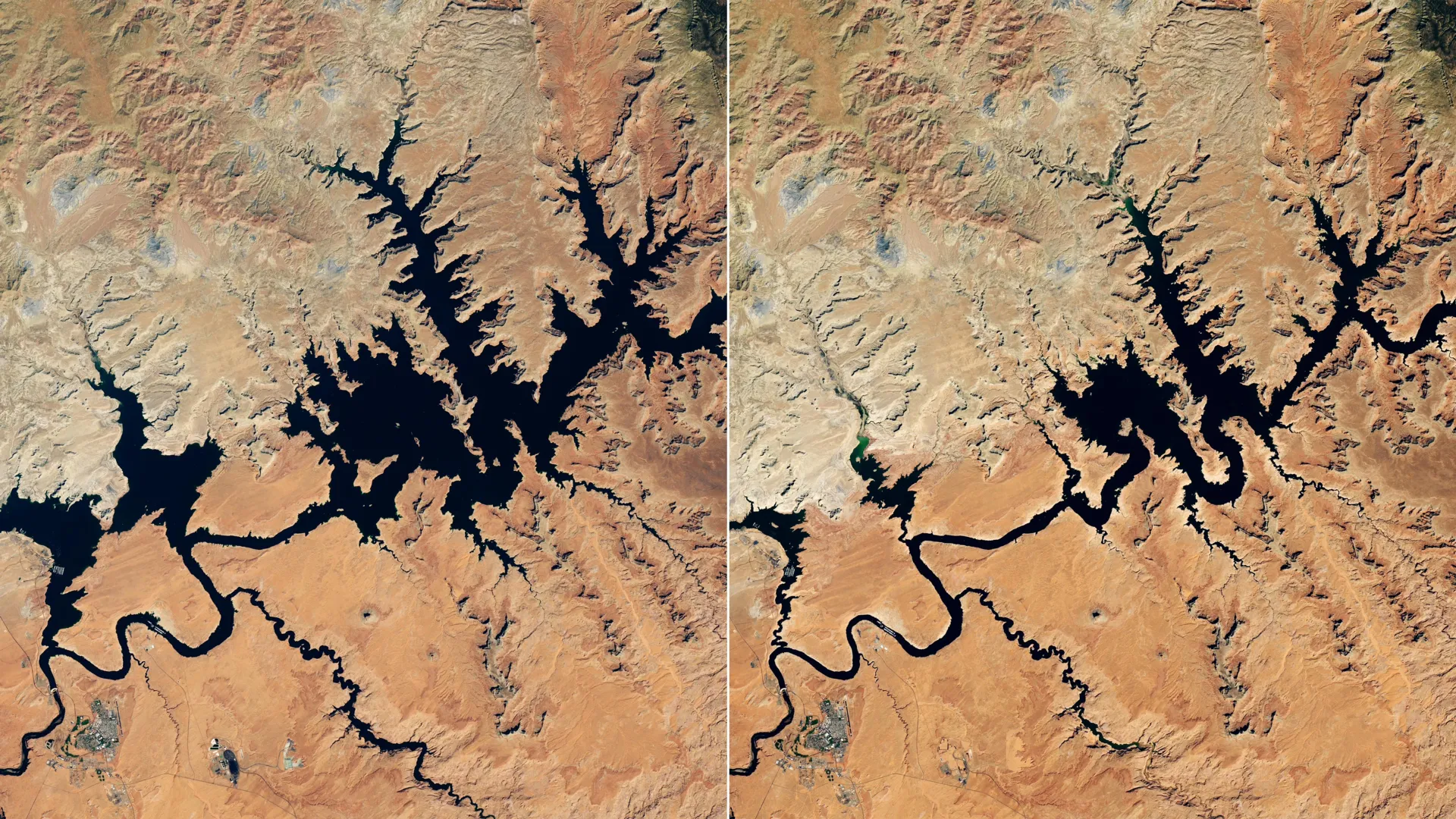
Lake Powell descended to historic low water levels during late summer following an exceptionally weak snowpack across the Upper Colorado Basin during the 2025-2026 winter season. Warm temperatures and limited mountain snow reduced the volume of meltwater flowing into the Colorado River system, which supplies water to the massive reservoir located near Glen Canyon Dam. By early September, the water surface elevation at Lake Powell measured 3,517.24 feet, falling below the previous record low of 3,519.92 feet established in April 2023.
Downstream, Lake Mead also experienced record-low conditions during August. The Colorado River system, which both reservoirs are part of, serves as a vital resource for over 40 million people across the Southwest, including residents of major cities such as Las Vegas, Phoenix, Los Angeles, and San Diego. The system additionally supplies water to approximately 5 million acres of agricultural land and generates hydroelectric power for the region.
Mountain snowpack proves especially critical to the Colorado River’s function because much of the basin receives minimal rainfall. Snow accumulated at high elevations during winter typically melts during spring and early summer, providing the majority of the river’s annual water flow. The 2025-2026 winter brought unusually scarce snowfall to the Upper Colorado Basin and other mountainous western regions, constituting a significant snow drought. Abnormally high temperatures compounded the problem by accelerating melt rates and reducing overall water availability.
In response to declining reservoir levels, the U.S. Bureau of Reclamation implemented emergency measures beginning in April. The agency increased water releases from Flaming Gorge Reservoir in northern Utah and southern Wyoming while simultaneously reducing outflows from Lake Powell to downstream Lake Mead. Officials also postponed scheduled environmental management activities, including a controlled flood designed to restore fish habitat sandbars and a specialized water release intended to protect native species.
The region continues experiencing a prolonged megadrought that began around the start of the 21st century. Water managers utilize NASA-supported monitoring systems and satellite data to track drought conditions, snow water equivalent, soil moisture, and other environmental indicators. Tools such as the Western Land Data Assimilation System, the Drought Severity Evaluation Tool, and the Colorado River Integrated Assessment system provide real-time information to support decision-making across the basin.
Article Attribution | Read More at Article Source
Article summary produced by Claude AI